

There have been Duffy’s on Duffy’s Creek since March 9, 1955. There have been people on Duffy’s Creek since about 4600 B.C. So the existence of people has a long and colorful history here, though the existence of too damn many people is a relatively recent phenomenon, out of which I was born in 1963, the youngest of five children, an unwitting part of the problem.
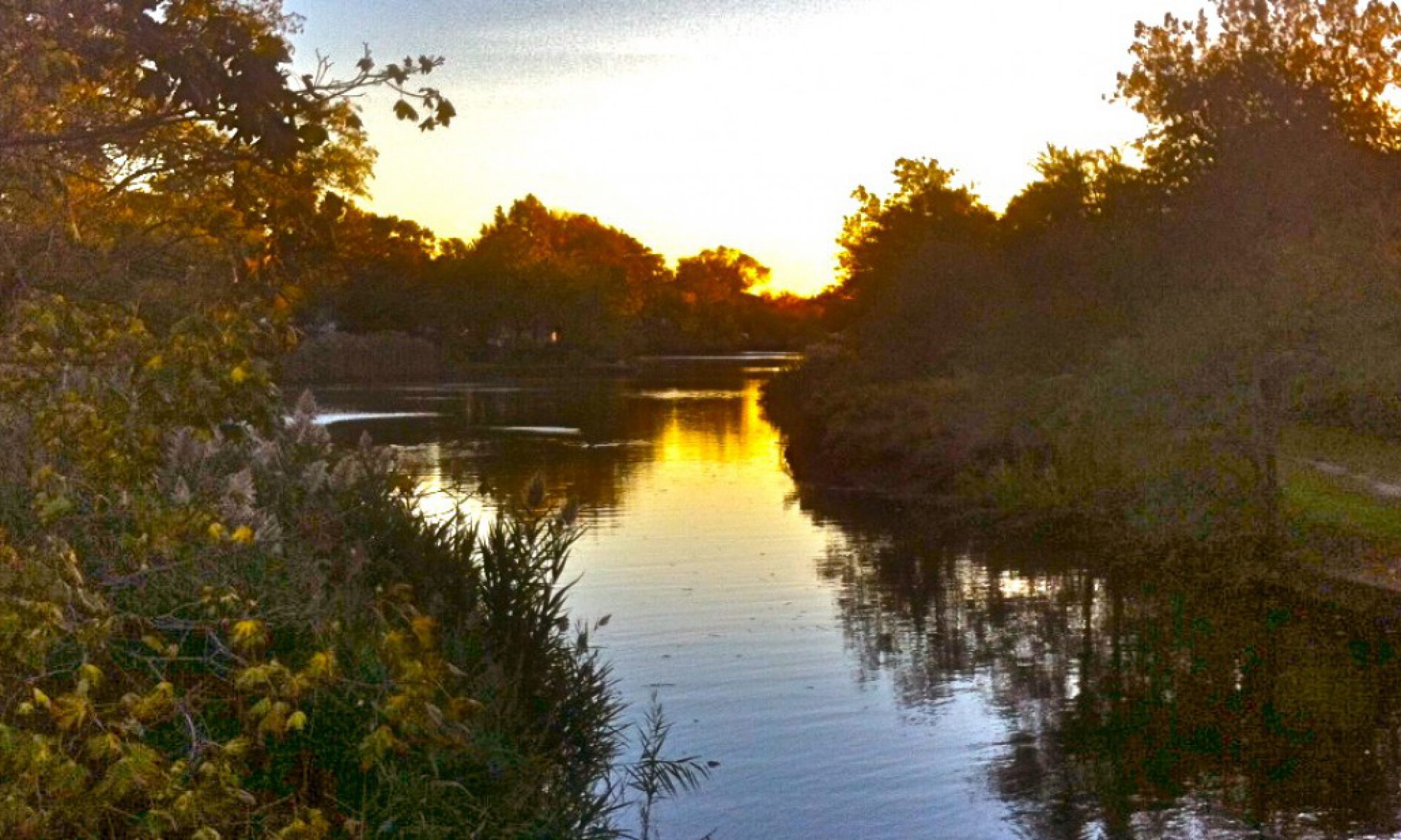
On summer nights, Trisha and I sit out in the backyard, and we talk some, while alternately staring at our little light-up magic rectangles and staring through the flowers towards the sunset over the creek. I like to imagine a Rockaway Indian couple sitting right in this spot in summer twilight a thousand years ago, without the stupid iphones and kindles, maybe listening to the “crawwwk!” of night herons, or watching swallows and bats circling the orange sky, or just watching the flow of the creek, the same tide and the same current, and maybe some of the same water molecules as we look at today, but maybe without so much spam in them.
But I don’t have to imagine being a little kid a hundred years ago, before the sprawl, walking into a deep, majestic forest at the end of Westwood Road in Woodmere, walking less than three miles to emerge from that forest into a farm field that overlooked this creek. I don’t have to imagine it at all because about ten years ago I discovered a book titled The Lord’s Woods: The Passing of an American Woodland written in 1971 by a noted birder and naturalist named Robert Arbib. And Mr. Arbib told me all about it; what this place was like for thousands of years before cape cods and split levels ate it alive. And we’ve become friends, though he died twenty years ago, because I love learning about the history of places, and I’ve spent a whole lot of time hanging around this one. And so did he. I like him and I think he would’ve liked me. 
A little disclaimer before I go on: I know a lot of people who are passionate about digging up the history of Valley Stream and the surrounding area, and some of them will read this post and want to point out possible discrepancies. (Gleefully). Please just relax. This is but a jumble of the stuff I know from reading Mr. Arbib’s book and a whole lot of other stuff, including stuff from the Hewlett-Woodmere Library website and the Valley Stream Historical Society Facebook page , called “Valley Stream of Yesteryear.” (You’re all wonderful people, and thank you for uncredited pictures, but you didn’t credit them either). I also know some history from my mother, who wrote the Valley Stream Historical Society newsletter for ten years or so, and my father-in-law, Jack McCloskey, who visited this neighborhood in the 1930’s for watercress and garden lime. But this is definitely not meant to be the definitive history of anything. (And by the way, it would be much easier to refer to Robert Arbib as “Bob” from here on in. “Mr. Arbib” sounds like I’m trying to be the New York Times, and I happen to know that his friends called him Bob. Anyway). What I am trying to do here is to put words and context to the pictures that I can I see in my mind sometimes when Mookie and I go walking.
Everybody knows us, Mookie and me. We’re local characters, and we’re proud of that. One sunny day in the middle of last winter, a woman called out to me from a car on Wood Lane as Mookie was reading his pee mail. She said, “you two really get around, don’t you! I see you everywhere!” I said, “Yes, yes we do.” And Mookie looked up and wagged his tail.
I knew at that moment that I had achieved my ultimate purpose in life: Being a local character. I’m the slightly crazy looking thin man with the very large happy yellow lab who you see walking around South Valley Stream all the time. But Mookie, of course, is superior to me in so many ways, particularly in his full-minded commitment to The Here And The Now. He’s living in the present when we’re out walking because he’s a dog, and that’s what dogs do, which is why they’re so much better than us. I try to stay in The Here And The Now, but I’m just not Mookie and I never will be. Often I’m living in the future as we’re walking, figuring out what things I can turn into things I’ve already done in the hours and the days ahead. But sometimes I’m living in the past, imagining what this place was like before the cars and the trucks and the poles and the lights and the wires and the fences and the signs and the asphalt and the whole rest of it. And it makes me wistful for a place I never knew, even though I’m walking through the middle of where it was; a place that, had it not been altered forever in the decades before I was born, actually would have made me as I know me impossible.

Bob’s story starts in 1920, as a nine year old boy exploring the woods that actually stretched from Lawrence to South Valley Stream, which he learned were called The Lord’s Woods after the very rich, successful lawyer who had owned the land at one time. (There’s a Lord Avenue way down in Lawrence in the area behind Rock Hall, where nobody ever goes unless you’ve got business there or you’re lost. It’s quite a beautiful area). The woods that Bob and his friend begin to explore stretched from about three miles southwest of here just about to my backyard. The entire Lord Estate stretched back through Cedarhurst and Lawrence all the way to Far Rockaway. My son is twelve and we can’t yet in good conscience let him cross the four lane road (Mill Road) that separates us from the rest of the world. Once upon a time, Mill Road was where the woods thinned out and the farms started. Bob and his friend walked through the woods, teeming with hundreds of different bird species and happy little animals. They discovered cool stuff like an Indian marker tree that was bent on purpose to indicate a trail, and a rope swing along a brook in the middle of nowhere. They crossed streams and marshland and followed along a dirt road until the realized they were following a gigantic water pipe, half-buried in the ground. The pipe led them to the “waterworks”, the Long Island Water Property, where the last little postage stamp of woods remain to this day.


They realized that the Water Company actually owned all the land that they were walking on. and that the land was kept undeveloped because they needed to pump water from under it. (One of the main reasons they ultimately sold it off to development and bulldozed it was that the technology was developed to dig deeper wells, thereby needing less land to protect the aquifers). But people had been trespassing on and enjoying these woods forever, and Bob and his friend soon found like-minded young nerdy fellows who liked identifying birds.
I like identifying birds. When Trisha and I first took over at Duffy’s Creek, we started keeping track of how many different bird species we could attract, including the waterfowl, who just hung around with us because we have a creek. Over the course of three or four years of keeping neat little notebooks (before we became parents and chaos ensued), I counted somewhere around 105 different species. Many of them just showed up once or twice, inexplicably, like a Brown Thrasher or a Tri-Colored Heron. But in The Lord’s Woods, apparently all these birds were as common as pigeons. And this is how Bob became a famous orthinologist, and how I helped get Andrew Cuomo to promise South Valley Stream $3 million dollars to help rehabilitate the Left Bank of Duffy’s Creek, money which he may or may not be still holding on to, because they haven’t spent it yet. I suppose because he’s not up for re-election. But that’s a story for another post.
In the first half of The Lord’s Woods, Bob tells the story of his youth through his seasons exploring own local primitive wilderness. As a guy who likes birds and plants and stuff, I just ate it up. There’s also a particularly gut-wrenching storyline about showing his first girlfriend all the secrets of The Lord’s Woods, then losing her to a car accident several years later when she was away at college, which was absolutely heart-breaking to read. Nonetheless, It’s all beautifully written, and topped off by a really cool map (pictured below) that helped me follow exactly where he was (and what is there now) as he describes his discoveries. I live along what is called Mott’s Creek or Foster’s Brook on the map. When I was growing up, my father told me it was called Watt’s Creek. On USGS maps (United States Geological Survey) it’s called “Valley Stream”. About fifteen years ago, when I had some time on my hands, I wrote to the USGS and tried to get it changed to Duffy’s Creek. The nice man from the USGS patiently explained to me that: 1) The don’t use apostrophes, which was a total buzzkill, and 2) I would have to die. I know that Foster, Mott and Watt were also local characters who just started calling the creek by their own names, so until I die and someone does the paperwork, that’s my plan.

In the middle of the book, as Bob is still grieving for his lost love, first the Hurricane of 1938 and then a giant fire decimate the woods. (I’ve seen more than once what a big hurricane can do to big trees). And the omens begin to rise around this same time: Giant electrical transmission towers go up, and surveyor marks plot out Peninsula Boulevard (which you can see on Bob’s map cuts right through the heart of what he called The Big Woods).

A wilderness would eventually recover over time from a natural disaster, but it didn’t stand a chance against the the post-WWII boom, and it is this point in the story where the book rises from beautiful to powerful and unforgettable. In the chapter entitled “Boom”, Bob begins:
“It was not fire that destroyed the Lord’s Woods. Fire and storm, blizzard and drought, even hurricane and flood were all natural events in the woods’ long history, often experienced and somehow survived, their wounds slowly self-healing and finally obliterated in forgiving beauty. Before the final act could be staged and the curtain rung down on the last of the drama that had been unfolding here for thousands of years, there had to appear on stage the villian of the piece – modern man – and there had to be a motive. It was not fire or storm that came to destroy our woods. It was greed and duplicity, avarice and ignorance and apathy.”
The “Boom” chapter, and the following chapter, called “The Threat” take you through a truly American story: How people saw what was happening to the woods and tried to stop it, and other people laughed and said “Fuck you. We’re doing it anyway.” As more and more of the woods were being bulldozed for development, people began to realize that “what remained was the only remnant of wet woodland left” in Southwest Nassau County, “the only place where one cold lose himself from the frenetic world and be an Indian brave or a Thoreau, a Daniel Boone or a John James Audubon, or just oneself, a child learning about the world around him.”
Here’s the short version: In 1955, the year my parents bought a house on a creek in a five-year old development of cape cods, the Lord’s Woods had been reduced to a box bordered approximately by, from what I can tell, Gibson Boulevard, Peninsula Boulevard, Woodmere Middle School, Hungry Harbor Road, Rosedale Road and Duffy’s Creek. The entire neighborhood of North Woodmere came after West Sunbury, so the ancient woods probably met the Hoeffner Farm all the way down Rosedale Road and went along Doxy Brook and blended into marshland as it got closer to Jamaica Bay. And in the other direction, I know for sure that there was a scout camp on the land where Peninsula Shopping Center sits now. You would need a lot of trees for a proper scout camp, so that was likely part of the woods as well. The neighborhood of North Woodmere on the opposite side of Rosedale Road from ours has bigger trees, because it was a woods and this was a farm. (I figured this one out all on my own).

The community got wind of a deal between the water company and a developer to buy up and bulldoze what was left of the Lord’s Woods. Bob tells of a woman named Helen Bergh and a man named Ben Berliner who were the leading forces in trying to save the woods, working with the Audubon Society to develop ways that the area could be used as a sanctuary and interpretive nature center. As the last acres of what was by that time called the Woodmere Woods were being eaten up, Helen Bergh (what a great name) led the Woodmere Woods Conservation Committee. They tried everything. New York didn’t want it for a state park. Nassau County didn’t want it. Officials from the Town of Hempstead suggested they would consider a park if Bergh, Berliner and their committee could show a public consensus for saving the last virgin woodlands in Southwestern Nassau County. But as Bob points out, “to prove that all people, everywhere wanted an esoteric amenity like a public wildlife preserve in 1956 was no easy task.” Some people wanted a park with lots of ballfields and tennis courts and swimming pools, which they eventually did get in North Woodmere Park. Other people, newer arrivals to the area, “would let the developers proceed; homes and gardens were more desirable neighbors than thickets of poison ivy and rat-infested woodlands where rapists can hide.” There wasn’t much you could do to convince people who had such disregard for the concept of open space that it would be in their interest to have a large undeveloped area around them. They’d no doubt never go in it anyway. Mosquitoes. Rapists. Very unsafe. Best to stay in the air conditioning.
By 1957, Helen Bergh had joined forces with a neighbor and friend who had also grown up enjoying the woods. His name was Edward S. Bentley. Together, they wrote a bill to present to the New York State legislature giving the Town of Hempstead authority to create a park district out of the Woodmere Woods. Before they could find sponsorship for the bill, the Water Company sold the land. Bob describes a race between the bulldozers, chain saws and graders, moving “like an invading army into the Lords’ Woods. One by one, the century-old oaks, maples, tulips, hickories, ashes and sweet gums crashed to the frozen ground.”
Sudddenly, as the woods came crashing down, people started paying attention to the destruction of the woods. Newsday was an up and coming newspaper at that time, according to Bob, and they took up the cause, but “while the editorial pages endorsed the principles of conservation and preservation, the business section, real estate section and its general news rang with announcement after proud announcement of the latest shopping center, housing development, industrial park, power station, highway expansion, population growth, property values and prosperity…No one was talking about the intangible cost of smog and summer heat, and the deprivation of natural beauty and an oasis of solitude and silence. Quality of life was of little concern to most people in 1957.” I’m sure if my parents knew about this story, and I’m sure they did, they were too busy to even think about joining a fight to save some woods.
Needless to say, the park proposal was shot down. Bob points out several bad guys in the tale, including lawyers and elected officials who were working both sides of the fence, pretending to help Mrs. Bergh’s cause for the public support it would bring them and working with the developers to destroy the woods at the same time. By the end of 1958, five years before I was born, the Lord’s Woods were completely gone. There is a little postage stamp of woodland around the waterworks, and some land that creeps up behind backyards up Doxy Brook to the reservoir on Hungry Harbor Road. When I was a kid, we’d sneak into those woods sometimes. My older brother and his friends used to catch turtles, bring them back to the house, paint their initials on the shells and set them free again. Today, most of it has barbed wire around it. And apparently, If I see something, I should say something. I assume it would be about what I saw, but I can only see though the fence, and there’s not much to see.


When I was younger than my son is now, I would go off in the summertime on my bike searching for rabbits in the parkland built behind the backyards in the Green Acres neighborhood, which is across Duffy’s Creek from our own neighborhood, which was called West Sunbury when Mr. William Gibson’s company built it in 1950. When I was a little older, I would take the aluminum rowboat from our backyard and row it down to Rosedale Road, pretending I was an Indian paddling along the creek. You could “park” the boat and climb the bulkhead into Brook Road Park in Green Acres. About twenty years ago, maybe more, they changed the name of the neighborhood to Mill Brook, because the residents did not want to be associated with the gargantuan shopping mall that sits right next to it (The same developer, Channan Corporation, built the houses and the shopping mall on land that once once divided between the Hoeffner Farm and Curtis Field, a famous airfield in the 1920’s that was visited by Ameliah Earheart and Charles Lindbergh. There’s a plaque in the middle of the Home Depot parking lot you could go look at if you don’t believe me).  The shopping mall is still called Green Acres, and it’s about thirty times the size it was when I was a kid. I may be exaggerating there a little bit. All I can tell you is that there aren’t any kids looking for rabbits or pretending to be Indians around here anymore. Lately they’ve been looking for Pokemon.
 Mr Gibson built our house. Thirty years before, he bought up a wooded area north of the farms and south of Sunrise Highway (which apparently was a hunting ground up until that time, though I don’t know who was hunting what) and built a planned neighborhood south of Sunrise Highway and north of the Lord’s Woods. Some of the houses were brick capes, but most of the houses were called “Gibson Colonials”. I’ve been in lots of Gibson Colonials
 , and they’re great houses. Before the 1920’s were over,
  Gibson started building bigger, pointy colonials on Munroe Boulevard and the surrounding streets. They’re great houses, too. In the middle of it all, he built his own Long Island Railroad Station in 1929.
 After World War II, Gibson bought up some more farmland and built hundreds of cookie-cutter capes and rickety ranches. Not as big as the colonials, but darn comfy, and with slightly less claustrophobic backyards. My parents bought a cape from an original owner who left after five years (for a bigger house). Gibson cranked out South Valley Stream in the course of thirty years. Our house was built in 1950 on what was the a small patch of woods at the edge of potato fields belonging to Reising Farm, which was divided between the Gibson development called “West Sunbury”, Harbor Road Elementary School (later renamed Robert W. Carbonaro School) and Valley Stream South High School.
Three houses still exist on Hungry Harbor Road right around the corner from here that predate Mr. Gibson’s West Sunbury neighborhood and the North Woodmere neighborhood that begins just south of it. (The name Hungry Harbor goes back to the 17th Century, and referred to squatters who lived on the land). One of the houses (the red one below) is condemned, but there may or may not be a guy still living in it. And don’t think I don’t now his name, because I do, because you learn things when you hang around a place for 53 years. I’m just not telling you about him because I feel sorry for him. You can see “the farmhouse” from our front yard. Close enough that you could holler across the potato field from the back step and tell Pa supper was ready if he were standing in our backyard. It must have been beautiful. There was actually a buffer of woods between the field and the creek, which is tidal and would probably eat your potatoes if you planted them too close. You could probably take a quick swim in the creek and not smell like the back of a garbage truck when you came out.


My late father-in-law, the great Jack McCloskey, was a nursery man. His father started McCloskey’s Florist and Nursery in Rego Park Queens in the 1920’s. When Jack visited our house for the first time, I thought he would enjoy knowing that you could see the farmhouse from our front yard. The farmhouse has a large outbuilding. Not really a barn but more like a series of attached garages. Thanks to Jack McCloskey, I now know that in the 1930’s, he would ride out to Valley Stream with his parents, where his Dad would buy the garden lime the Reisings sold wholesale out of that building and he would pick watercress along the creek with his mom. We were standing in my driveway when he told me what he remembered. We would have been in the trees at the end of the potato field.

At the end of the chapter of The Lord’s Woods when Bob recounts how the last of the woods were lost, he interrupts the narrative and takes you back all the way to the glaciers to drive home the point of what was lost when those chain saws and bulldozers attacked the Lord’s Woods. He includes the ancient history of the place to illustrate just how disgusting the systematic destruction of this land for tract housing really was, how parts of the area surrounding me were literally untouched from before the birth of Christ until just after the arrival of Francis and Joan Duffy. He describes the arrival of the Rockaway Indians, a great bunch of people with a really cool name who showed up here around 1000 b.c. “For centuries untold, these people lived on these lands and waters making no destructive impact on the environment…They belonged to the woods and were as much a part of it as the turkey, the bear and the wolf.”
Of course, once the English Settlers showed up in the 1600’s and created Ye Olde Town of Hempstead, the jig was up for the Rockaway Indians. Within about two hundred years, in 1818, the last of the Rockaways, an old man named Culluloo Telewana, died in his little house in Woodmere. 70 years later, a local man named Abraham Hewlett, who “was enthralled with his stories as a boy” erected a monument to Cullulo Telewana. As Bob points out in The Lord’s Woods, “It is the only memorial to a 7,000 year history to be found anywhere.” And here it is:
And so Mookie and I go for a walk a hundred years ago, in 1916, before Gibson, before Curtiss Airfield. It’s very, very quiet here. We start at the creek and walk through a small patch of woods until we’re walking along farm fields towards Mill Road. We cross the dirt road and stroll beside the mill on Watt’s Pond. Mookie jumps in for a quick swim while I watch the ducks fly off. We walk back along the dirt road, maybe seeing people out working in the fields. The land is completely flat, so you can see the farmhouse all the way from the pond. Mill Road disappears into the woods. We walk through a cathedral of trees along an old Indian path. Maybe it’s the end of October, and the leaves are on fire as they rain softly from the giant trees, and the autumn sunshine streams down, bringing the whole scene into sharp focus and preposterous color, like an old Kodachrome print. We walk about as far as Peninsula Boulevard then we turn around and head back to the 21st Century, our footsteps and birds singing around us the only sounds we hear. Yes, folks, there could have been a beautiful, majestic nature preserve right in my backyard, an ancient woodland preserved for the benefit of my son, his son, his grandson and all our dogs. But as Bob Arbib writes at the end of the final chapter of The Lord’s Woods, “greed and apathy, deceit and arrogance, ignorance and blindness to future needs had finally done their dirty work.”


One of my favorite passages from The Lord’s Woods appears on page 175, when Bob is explicitly expressing his opinion of my neighborhood, the place my parents fell in love with, the place my son loves. This is how he saw it:
“North of the woods along the Old Grey Road (Rosedale Road was its official name) the farms were disappearing fast…Grids of roads were slashed across them and the houses went up blocks at a time, more densly crowded, more monotonously uniform than anywhere around…I looked upon them as rural, ready-made slums, quickly and badly thrown together…they were sold and occupied as fast as they were built. This was a sorry wasteland, now, with no single inhabitant of any of those tacky boxes who could remember what had once been here: The corn, the rows of lettuce, the potatoes, the bluestem grass. No one could remember a horse and buggy shooting up banners of yellow dust as it raced along, one summer’s morning years ago.”
I can remember it, Bob. I can remember what it looked like, even though I wasn’t there, and I’m part of the reason it’s gone. I see it sometimes when I’m out walking my dog. It’s beautiful here.

